Air-Sea Interactions II
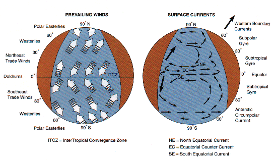
I. General Circulation Caused by Coriolis Effect
- prior to Coriolis effects, heat in atmosphere is transferred via:
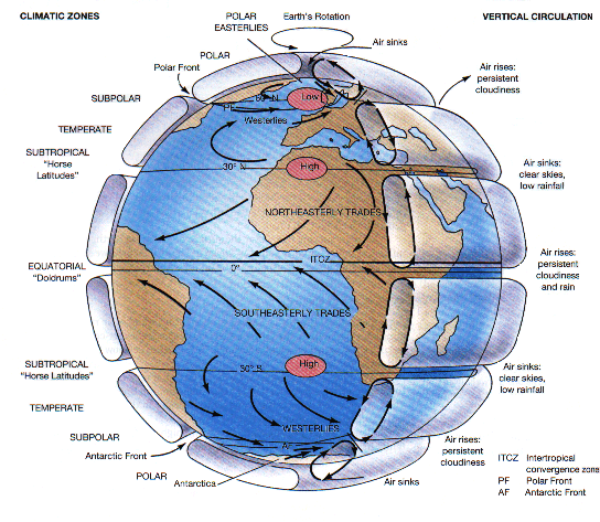
- greater heating of the atmosphere over equator causes air to expand, become less dense and rise; as it rises it releases its water vapor -- this is a permanent low pressure belt
- warm equatorial air then travels some distance north and south of equator and descends in subtropical regions around 30° latitude; when it descends, it becomes compressed and denser and creates a high pressure belt in subtropics
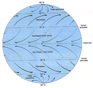
- this descending subtropical air spreads along earth's surface both back towards the equator (these are the trade winds, between 0-30° N or S) and also to higher latitudes (westerly wind belts, 30-60° N or S)
- the westerlies rise over the dense cold air moving away from the polar high-pressure caps (the polar easterly wind belts) -- they rise at a subpolar low pressure belt located at 60°
- the air that rises at 60° latitude cools by releasing water vapor and then descends in the polar regions or the subtropics
- NOTE: where warmer air rises, you get low pressure belts; where colder, denser air descends, you get high pressure belts
- where the trade winds converge (as they are both rising in the Northern and Southern Hemispheres), atmospheric upwelling occurs and sea level winds are light and variable; cloud cover is persistent and rainfall is high -- these are the doldrums or the intertropical convergence zone (hurricanes and typhoons originate just above here)
- between a Hadley and Ferrel cell, winds are descending (there's a downwelling), but they descend in opposite directions -- here winds are light, skies are usually cloudless, and rainfall is low -- these are the horse latitudes
- Coriolis effect causes deflections (to the right in Northern Hemisphere and left in Southern Hemisphere), but magnitude of these deflections depends on latitude because the rotational velocity differs with latitude
- contrary to what you may think, intensity of the Coriolis effect increases as you move towards the poles (not towards the equator) -- why?
- not interested in absolute velocity, but rate of change of velocity -- there is a difference of 200 km/hr in velocity from equator to 30° latitude; a difference of 600 km/hr from 30 to 60° latitude; a difference of 800 km/hr in velocity from 60° to the poles
- because of these velocity changes and the increase in the Coriolis effect, air movements in the polar cells are more complex
- get formation of jet streams that are swiftly moving west-to-east currents high in the atmosphere that are located over the boundaries between a Ferrel and polar cell (or polar front)
II. Seasonal Variations in the Winds
- because earth's axis is tilted and hemispheres take turns leaning into the sun throughout the seasons, air over continents gets colder in winter and warmer in summer than air over adjacent oceans
- thus, during winter, continents usually develop atmospheric high-pressure cells, while in summer, they develop low-pressure cells
- but because of water's high heat capacity, it takes a large amount of heat to warm the ocean surface waters; there is a time lag between sun's seasonal movements and movement of atmospheric convection cells (this is why northern countries have their warmest weather in August and their coldest weather in February even though summer solstice occurs in June and winter solstice occurs in December)
- time lag is less over a continent because heat captured from solar radiation is transferred to atmosphere more rapidly by land
- because the continents are concentrated in Northern Hemisphere, seasonal migration of convection cells has a shorter time lag north of the equator than south
- as air moves away from a high pressure cell and towards a low pressure cell, the Coriolis Effects produces a counterclockwise flow of air around the low-pressure cell (cyclonic) and a clockwise flow of air around high-pressure cells (anticyclonic)
- wind patterns associated with continents will reverse themselves seasonally as winter high pressure cells are replaced by summer low pressure cells
- at high and low latitudes, weather stays pretty much the same, BUT at mid-latitudes, weather becomes interesting:
- warm & cold fronts: caused by contact of a warm air mass moving eastward into an area occupied by a cold front or a mass of cold air moving eastward into an area occupied by warm air
- warmer air always rises above denser cold air and water vapor in it condenses as precipitation
- cold front is always steeper so get more rainfall (usually briefly) than in a warm front
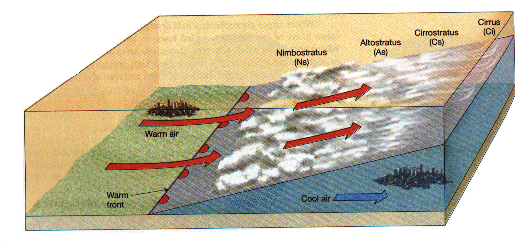
In a warm front, warm air rises above cold air, condensing as it does so to form clouds and possibly rain.
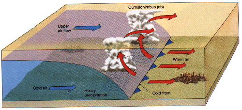
When a cold front approaches an area occupied by warm air, the warm air is forced up, causing that air to expand and cool; this cooling will lead to condensation of water vapor and rainstorms will result.
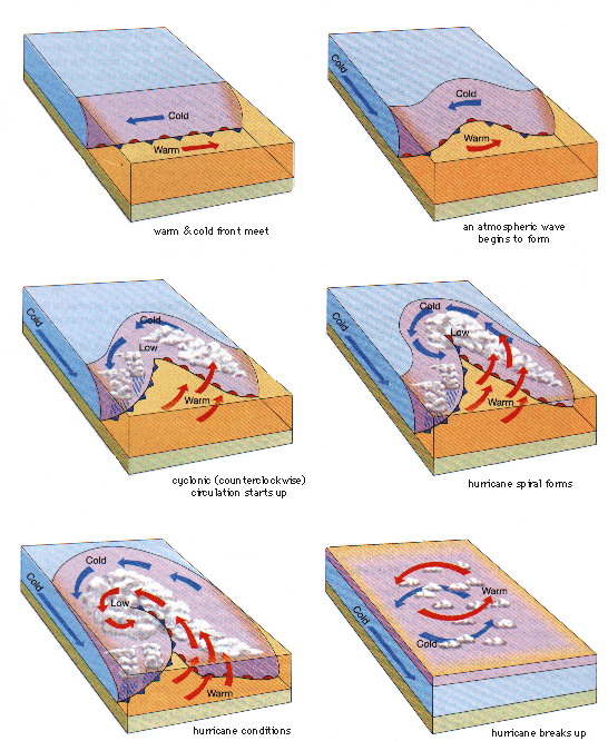
- Tropical cyclones ( Typhoons and Hurricanes): are formed from scattered thunderstorms of a tropical cloud cluster above very warm water (>26°C); they arise close to the equator, but far enough away for the Coriolis effect to exert a greater velocity and create vigorous eddies
- within the center or eye, winds are light; around the eye there is a wall-like updraft that creates lower pressure which then fuels the storm by bringing in more hot, damp air
- usually move westward but paths are erratic
- break up upon hitting land
- storm surges: results from a combination of high tides and rising sea level during periods of bad weather -- also characterized by low pressure systems that cause a bulge in the sea surface beneath them; these bulges and high winds cause high volumes of water to crash onto the shore (hurricanes can add to the winds pushing the water and water height)
- waterspouts: weak, tornado-like phenomena caused by a rapid updraft of air and the accompanying inflow of low-level air -- most of the water is not sucked up from the sea but is caused by water droplets that form as the moist, rising air cools rapidly; is short-lived
III. Motion in the Sea -- Currents
- when winds blow over oceans they set surface water in motion, driving the large scale surface currents in nearly constant patterns (differs from deep-sea circulation that is a result of changes in water's density)
- surface water is defined as water between the surface and thermocline in the deep ocean (~300-1000 m depth)
- since the density of water is greater than that of air, once in motion, the mass of moving water is so great that its inertial force keeps it flowing
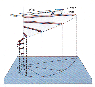
- they are deflected by the Coriolis force in same way that moving air is deflected, but because water moves more slowly than air, time required for water to move same distance is much longer and earth will have rotated farther out from under the water than from the wind; thus the deflections will be greater (45° greater than the angle of the wind)
- the wind's energy gets transmitted throughout the water column and sets each successive layer of water into motion; however each layer receives less and less wind energy so each has less and less velocity (note the arrows, which are vectors, decrease in size reflecting this velocity loss)
- nonetheless, each layer is deflected with regard to the one immediately above it and this results in a spiral of current directions called the Ekman spiral
- NOTE: in contrast to winds, a current is named for the direction in which it travels, not from which it comes
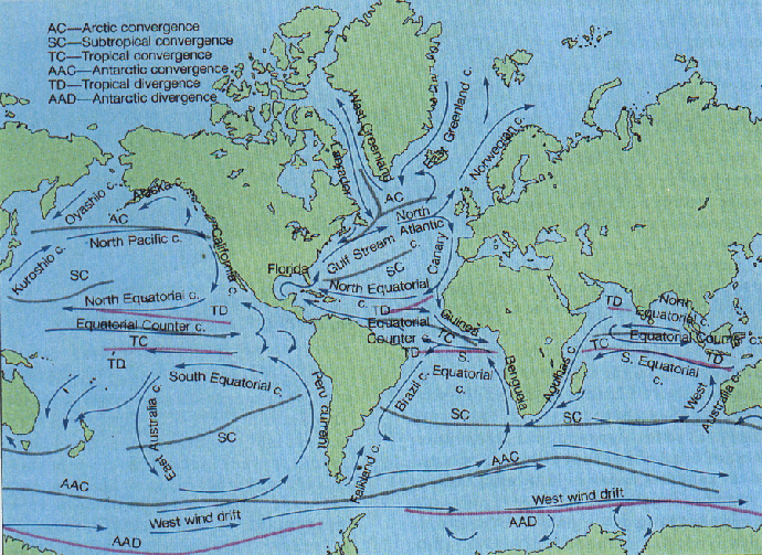
- each ocean gyre is made up of 3 separate currents:
- western boundary currents -- have a sharp boundary with coastal circulation; little or no coastal upwelling; waters are depleted in nutrients; unproductive; derived from trade winds
- eastern boundary currents -- diffuse boundaries; coastal upwelling; waters derived from mid-latitudes; flow toward the equator; weak currents
- equatorial currents -- complex at edges of ocean basins; seasonally variable and move northward in the summer
- North Pacific Currents: less affected by continents here than in the Atlantic because the Pacific is larger
- in North Pacific, northeast trade winds push water toward the west and northwest; this is the North Equatorial Current (flows west towards the Philippines and north to ~12°N)
- westerlies create the Pacific Current or North Pacific Drift, moving west to east (moves water away from Asia and pushes it towards west coast of North America)
- because water that accumulates in one area must flow toward the area from which it has been moved, two other currents are formed: California Current (moving north to south) and Kuroshio Current (moving from south to north) along the east coast of Japan
- the Equatorial, North Pacific Drift, California and Kuroshio currents complete a circular, clockwise motion centered around 30° N latitude -- the North Pacific Gyre
- other Pacific currents include the Oyashio Current, driven by polar easteries, the Alaska Current fed by the North Pacific Current and moving in a counterclockwise gyre
- South Pacific Currents:
- the southeast trade winds move water to left of the wind and westward, forming the South Equatorial Current
- the westeries push water to the east and produce the West Wind Drift which moves water almost continuously around the earth, but is partially deflected by the southern tip of South America and Africa
- continuity currents (currents replacing water that has been pushed away) form between the South Equatorial Current and the West Wind Drift: these are the Peru (or Humbolt) Current, moving water from south to north along the coast of South America, and the East Australian Current, moving from north to south on the west side of the ocean
- these four currents produce the counterclockwise South Pacific gyre
- the North and South Pacific gyres are formed not on either side of the equator, but on either side of 5°N, because the doldrum belt is displaced northward due to the unequal heating of the Northern and Southern Hemispheres; there is a current moving in the opposite direction, from west to east, known as the Equatorial Countercurrent, that helps to return accumulated surface water eastward across the Pacific
- North Atlantic Currents:
- the North Atlantic westerly winds move water eastward in the North Atlantic Current or North Atlantic Drift
- the northeast trade winds push water to the west, forming the North Equatorial Current
- the north-south continuity currents are the Gulf Stream, flowing northward along the coast of North America, and the Canary Current, moving to the south on the eastern side of the North Atlantic (the Gulf Stream is fed by the Florida Current and the North Equatorial Current)
- these four currents produce the North Atlantic Gyre, which rotates clockwise
- the polar easteries provide the driving force the Labrador and East Greenland currents that balance water flow into the Arctic Ocean from the Norwegian Current
- South Atlantic Currents:
- the westeries continue the West Wind Drift
- the southeast trade winds move water to the east and forms the South Equatorial Current, which is deflected somewhat by the bulge of Brazil and flows into the Caribbean Sea, the Gulf of Mexico, as well as forming the Florida Current
- a portion of the South Equatorial Current is deflected south to become the Brazil Current
- the Benguela Current moves northward up the African coast
- these four currents form the South Atlantic Gyre which rotates counterclockwise
- Indian Ocean Currents:
- mainly a Southern Hemisphere ocean, so the southeast trade winds push water to the west, creating the South Equatorial Current
- westeries move the water eastward in the West Wind Drift
- the counterclockwise gyre is completed by the West Australia Current, moving northward, and the Agulhas Current moving southward along the coast of Africa
- northeast trade winds drive the North Equatorial Current to the west and the Equatorial Countercurrent returns water eastward toward Australia