Ocean Circulation II
I. Thermohaline Circulation
-
need to understand temperature-salinity
relationships in order to understand how they can influence current
patterns
-
at the surface, temperature of coldest
waters is controlled by temperature of initial freezing of seawater, while
warmest water temperatures are controlled by evaporation of water
-
salinity at the surface also shows a relatively
limited range, between 33 and 37
-
below surface, temperature and salinity
vary together in characteristic ways for the region in which the waters
formed
-
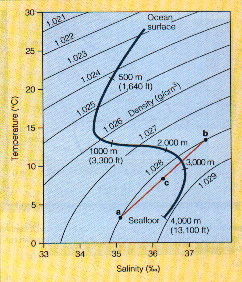
the curve of temperatures and salinities
are called a T-S curve and can be used to identify any given
water mass and to determine how water masses mix
-
thermohaline circulation
is composed of currents below pycnocline
-
these currents are driven by density differences
(cause water masses to sink or rise to their appropriate density level)
-
density differences are caused by both
temperature and salinity, which can counteract each other
(e.g., salinity has a minimal effect in equatorial regions because surface
temperatures are high enough to maintain a low water density at the surface
and to prevent water from sinking)
-
ocean waters are arranged in a series
of horizontal layers of increasing density--from surface waters to the
ocean floor
-
3 principal depth zones:
-
surface zone (mixed layer):
approximately 100-200 m thick; generally uniform or nearly uniform in density
-
pycnocline zone: where water
density changes markedly with depth; top of zone corresponds approximately
to 10°C contour while its bottom corresponds to 4°C contour; is
a stable zone because the vertical movements of water in the surface zone
and seasonal changes in temperature or salinity do not penetrate the pycnocline
-
zone in pycnocline where density is controlled
primarily by changes in temperature is the thermocline (this occurs
in open ocean water because salinity changes little there)
-
zone in pycnocline where density is controlled
primarily by changes in salinity is the halocline (this occurs in
coastal ocean areas where salinity changes dominate due to runoff and temperature
changes are less important)
-
in high latitudes (other than the North
Pacific and Arctic Ocean), there is no pycnocline because heat is lost
from the oceans exceeds heat gained from solar radiation; thus surface
waters are cooled and increase in density -- this forms the deep ocean
water masses
-
deep zone: contains about
80% of ocean's volume; except at high latitudes, the deep zone is separated
from atmosphere -- this isolation prevents interactions with the atmosphere
and warming of deep ocean water by solar heating; thus deep zone retains
its low temperature (3.5°C)
-
colder, higher density water sinks to
the depth at which the water below has an even higher density and the water
above has a lower density -- it then spreads laterally to form a thin layer
extending out from the source and pretty much stays as a separate water
mass (called salt lenses)
-
the lateral spread can be extensive because
density differences inhibit vertical movement and mixing; less energy is
needed for this flow than is needed for mixing or vertical movement
-
densest water masses are created by cooling
or freezing of surface waters in only a few locations at high latitudes;
formed by ice exclusion:
-
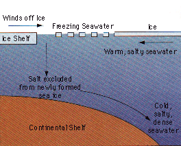
sea ice can only incorporate about 15%
of seawater's salt -- salt remaining in unfrozen water beneath ice forms
brine
-
occurs in the Weddell Sea (bay on Antarctica
opposite south end of the Atlantic Ocean); forms the cold, high salinity
water mass (-0.5°C; 34.65‰) called Antarctic Bottom Water
which sinks to the deep ocean floor and is transported eastward around
Antarctica; as it sinks it moves northward into each of the three major
ocean basins up to 45°N in N. Atlantic and 50°N in Pacific
-
also occurs in the Arctic Ocean, but topography
of that basin prevents most of it from escaping -- can't flow into Pacific
because of a shallow sill between the Aleutian Islands and the shallow,
narrow Bering Strait (which connects the Bering Sea and the Arctic Ocean)
-- can't flow into Atlantic Ocean either because of shallow ridges between
Scotland and Greenland
-
however, get cold water masses in the
Norwegian Sea and Greenland Sea which forms the North Atlantic Deep
Water (NADW) that sinks and flows south in vast quantities --is
one of the most voluminous masses
-
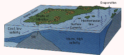
NADW has water of higher than average
salinity because large amounts of high salinity water are introduced from
the Mediterranean Sea (where more water is evaporated and less is added
via precipitation) and are carried into high latitudes by the Gulf Stream;
this makes NADW distinguishable from Antarctic Bottom Water, and, because
it is less dense, it flows over Antarctic Bottom Water

-
ocean thermohaline circulation has been
portrayed as a global conveyor where ~1000 years is needed
to make a complete circuit -- amount of water moved is ~20 times the combined
flow of all the world's rivers
-
major feature of this model is that deep
circulation is driven by the formation of highly saline deep waters in
the N. Atlantic
-
conveyor begins in the North Atlantic
near Iceland and Greenland where surface waters are chilled by the dry
winds of the Canadian arctic -- evaporation occurs here due to the dryness,
and leaves salt behind; this causes the waters to become more dense, sink,
and form the NADW which flows southward
-
once NADW reaches Antarctica, it flows
eastward around the continent and gets mixed with Antarctic Bottom Water
(1 part NADW and 2 parts Antarctic water; the mixing is called caballing)
-- it loses its identity about halfway around the continent
-
from there deep waters flow northward
into the Indian and Pacific Oceans -- here they gradually mix with other
warmer waters
-
some return to the surface via upwelling
around Antarctica
-
these upwelled surface waters return to
the Atlantic in known and unknown ways, but they mix with the surface waters
to form the mixed layer current system
-
some waters return by flowing through
the islands of Indonesia and then enter the Agulhas Current to return to
the Atlantic via the Cape of Good Hope (this transfers heat from the Indian
and Pacific Oceans to the Atlantic Ocean, which is why northern Europe
is warmer than it should be for its latitude location)
-
eventually the waters return to Greenland,
where they are cooled and begin the cycle again

-
ocean sediment records show that the NADW
conveyor belt has been turned off and on during the past tens of thousands
of years and that these switches have coincided with abrupt changes in
climate and extinction of marine forms
-
the hypothesis for this is related to
postglacial periods where glaciers melted and their freshwater runoff emptied
into the ocean -- the cold melted "fresh" water formed a stable, low density
surface layer over a large area of the North Atlantic Ocean; this formed
a cap, severely restricting formation of the NADW current and slowing the
conveyor belt; last ice age ended 13,500 years ago, but 11,000 years ago
there was a short cold period where the northwestern part of Europe's climate
became colder within a matter of decades and then rewarmed to its former
condition
-
once the glaciers finished melting, runoff
was reduced, low density surface water eventually became mixed, and the
NADW conveyor was able to start up again
-
the turn off of the conveyor belt causes
a new ice age as northern climates cool without the input of warmer Indian
and Pacific Ocean water
-
it is unknown if changes in the conveyor
belt cause climate changes or if climate changes cause conveyor belt changes;
BUT in 1980's, the annual rate of formation of the Greenland Sea Deep Water
(one source of NADW) decreased by about 90 percent (which suggests that
climate change may drive conveyor belt changes since greenhouse gases increased
dramatically during the same time)
II. Ancient Current Patterns
-
can reconstruct surface currents because
the prevailing winds are primarily a result of the heating of Earth's surface
in low latitudes and the cooling of the surface near the pole
-
ancient surface currents would thus reconstruct
as follows:
-
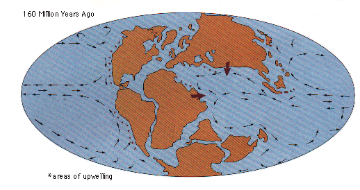
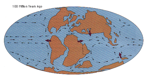
in narrow basins, winds and wind-driven
currents would parallel the sides of the basins; thus in the newly formed
Atlantic, winds were restricted to a north-south movement and so were currents
-
as the basin widened, winds blowing along
the north-south axis would weaken to form gyres via the Ekman spiral
-
after the Americas separated from Eurasia
and Africa, the connection between N. and S. America was still submerged
-- once the Tethys Sea opened between Africa and Eurasia (~100 mya), there
was a globe-circulating equatorial current system
-
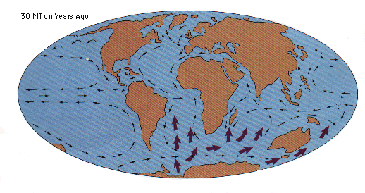
this equatorial current system continued
until the ends of the Mediterranean Sea closed when Africa and Eurasia
came together about 30 mya
-
then the land connecting N. and S. America
emerged and further disrupted the equatorial current system
-
40 mya Antarctica separated from Australia
and Australia moved northward and helped to demark the Indian Ocean
-
30 mya the Drake Passage between S. America
and Antarctica deepened permitting the Circum-Antarctic Current to flow
around Antarctica, which isolated Antarctica initiating the formation of
present ice cap and causing the present glacial climate
III. Ancient Subsurface Currents
-
have greater difficulty reconstructing
subsurface and bottom water formation sites because these are controlled
by details of the basin shape and by climate
-
when present cycle of mid-ocean ridge
spreading began (200 mya), earth had a warmer climate than present (poles
were much warmer and no sea ice formed); thus conditions did not favor
formation of cold, dense water masses because there was no chilling of
surface waters and no increases in salinity resulting from salts being
excluded from newly formed sea ice
-
dense seawater probably formed from evaporation
in basins at arid mid-latitudes that resulted in warm, but highly saline
waters (like the present Mediterranean and Red Seas)
-
during the past 50 mya earth's climate
cooled; at the beginning of this period, deep waters were probably 13°C
but have since cooled to ~0°C
-
once the Circum-Antarctic Current isolated
the shallow seas around Antarctica the climate cooled enough to permit
formation of sea ice (with ice exclusion of salts); Antarctic Deep Water
formed and moved northward into the Atlantic, Pacific, and Indian oceans
-
40 mya the Iceland-Faeroe Ridge (between
Greenland and Scotland) submerged which then allowed Arctic waters to flow
into the North Atlantic; this allowed the formation of the NADW and marked
the development of the 3 layered ocean


