Coasts I: Classification & Characteristics
- classification schemes vary, but are generally either:
- erosional/depositional: depending on whether their primary features were created by erosion of land or deposition of eroded material
- erosional coasts are those that developed where active erosion by wave action occurs or where rivers or glaciers caused erosion when sea level was lower than it presently is; these include cliffs or rocky shores
- depositional coasts develop where sediments accumulate either from a local source or after being transported to the area in rivers and glaciers or by ocean currents and waves; these include deltas, mangrove swamps, salt marshes, barrier islands, and beach-sand dunes
- primary/secondary
- primary coasts are generally young and are shaped by terrestrial processes, including erosion, river/stream deposition, glaciers, volcanism, and tectonic movements
- secondary coasts are shaped mainly by marine erosion or deposition due to wave action, sediment transport by currents, or building activities of certain organisms (e.g., reefs); generally these coasts are older
I. Primary Coasts
- formed by land erosion
- during the last glaciations, rivers cut across the land and eroded sediments to form coastal river valleys which then drowned when sea level rose again
- glaciers can have the same effect by scouring out steep-sided valleys and carrying sediments that are deposited where the ice melts at glacier's end (moraines); as sea level rose, the valleys were also flooded to form deep and narrow fjords many of which are partially closed off from the ocean by sills formed by moraines
- formed by land processes where sediment washes off the land to build out the coast
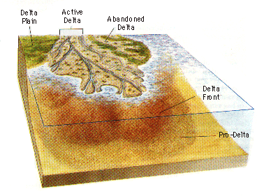
- deltas are formed when the sediment discharge from a river is so large that former estuaries become completely filled and wave and tidal current action are unable to disperse the sediment that reaches the river mouth; most deltas occur at mid- to low-latitudes and form extensive wetlands of high biological productivity and fertility
- a delta has the following features:
- delta plain: an extensive lowland area above sea-level, usually crossed by a network of active and abandoned channels which are separated by either vegetated or shallow water areas; channels are called distributaries which constantly change as sediment blocks the channel so that flow will split to form a new route
- delta front: comprises part of the shoreline and part of the delta below sea level where delta sediments dip seawards; this is where the river bedload is deposited and it consists most of sandy sediments
- prodelta: the deeper, offshore zone which receives much of the silt and clay that is transported seawards in suspension; generally merges with the shelf-sediment environment
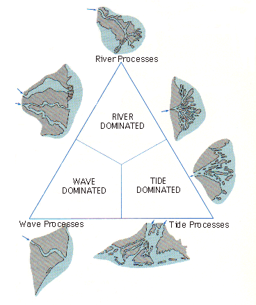
- there are several types of deltas:
- river-dominated deltas -- occur where the tidal range is very low and the tidal current action is very weak
- can have a situation where the speed of river's flow is moderate to low and the distributary mouth is relatively deep, allowing salt water (in form of a wedge) to penetrate upriver; river water spreads out over the surface of seawater as a two dimensional jet and mixing occurs at the base of the freshwater where it flows over the seawater and at the sides of the plume; get raised banks of sediments which diverge little as they are built seaward so their distributaries tend to be long, straight, and finger-like; also get density stratification
- example: Mississippi delta
- can also have a situation where the speed of the river discharge is so high that it literally forces the seawater back, causing turbulent mixing as it does so; no density stratification here
- example: Amazon river
- tide-dominated deltas: occur in regions where wave action is limited and tidal ranges are generally in excess of 4 m, generating strong tidal currents -- have a major effect on mixing of river water and seawater and on sediment redistribution; density stratification is prevented; two-way sediment movement occurs with the formation of sediment ridges parallel to the direction of the river flow; have a very ragged outline
- wave-dominated deltas: occur where wave energy is high; outflowing freshwater behaves as a countercurrent, slowing down oncoming wave crests and causing waves to break in deeper water than normal; waves are also refracted so that wave energy is concentrated on the freshwater plume -- this leads to vigorous mixing, rapid deceleration of the freshwater flow, and sediment deposition; wave action reworks the deposited sediments to form sand bars and beaches, creating a straight shoreline with only a small protuberance at the distributary mouth
- volcanic coasts: if an island, coastline will consist of lava flows that are weathered by waves; if on a continent, can get a concave shoreline from a volcanic crater (which results from a volcano exploding or collapsing) that fills with seawater
- fault coasts: occur where the crust is being warped or faulted -- when one side of the fault moves upward relative to the other side, the sea can intrude (ex: Gulf of California)
II. Secondary Coasts
- have high-energy and low-energy secondary coasts
- high-energy coasts are battered by large waves; more exposed to tropical storms; shore straightening occurs most rapidly here (wave energy focuses onto headlands and causes sediments here to erode and form beaches -- beaches modify irregular form of original shoreline and "straighten" it)
- low-energy coasts are infrequently battered by large waves; are more protected
- erosive forces form the following features along these coasts:
- sea cliffs -- marks shoreward limit of erosion; steepness results from the collapse of undercut notches
- sea caves -- cuts into cliffs at local zones of weakness in the rocks; can have a blowhole at top of cliff if erosion continues upward along a zone of weakness
- sea arches -- formed by erosion of rock
- sea stacks -- formed by a rock pile seaward from the beach
- wave-cut platforms -- marks the submerged limit of rapid erosion just offshore
III. Currents Affecting the Accumulation of Sediment on Secondary Coasts
- movement of sediment along the coast by wave action is called longshore drift; occurs in 2 ways:
- by wind driven movement of sand along the exposed beach
- most wind waves approach the coast at an oblique angle and then refract (bend) in shallow water to break almost parallel to shore; water will rush up the beach at a slight angle but will return to ocean by running straight downhill due to gravity
- this causes sediment to move up the beach at an angle but retreat down the beach straight down -- the net transport of sediment is longshore, parallel to coast and away from the direction of approaching waves
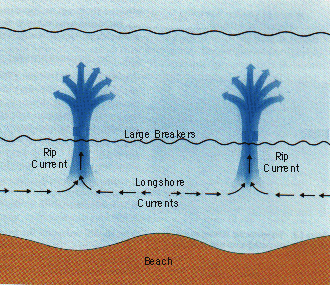
- by current-driven movement of sand in the surf zone just offshore (via longshore currents)
- when waves approach a straight coastline at an oblique angle a longshore current is produced which flows parallel to shoreline in nearshore region; current is produced by waves distributing a portion of their energy away from their direction of approach; they move sediment along the shorelines where there are gently sloping beaches
- rip currents can also occur -- are strong narrow currents with speeds up to 2 m/sec; formed when longshore currents move towards each other in the surf zone and converge -- water turns seaward as a rip current; during rip current circulation, sediment is moved along the shore by longshore currents and seawards by rip currents
- the converging longshore currents are caused by wave crests containing waves of different heights due to differential shallowing of seabed beneath the wave crest -- this sets up a horizontal pressure gradient between waves of different heights which then leads to the flow of water along the shore in opposing directions (flows from positions of highest wave heights to lowest wave heights)
- types include beaches, barrier islands, sea islands, sand spits, bay mouth bars
- sand spits form when a longshore current slows as it clears a headland and approaches a bay -- slower current in bay can't carry much sediment, so it is deposited in a line downcurrent of the headland
- bay mouth bars are formed when a sand spit closes off a bay -- occurs because a sand spit curls over at its tip when current-generating waves are refracted around the tip; eventually an inlet to bay may be cut by tidal action or by water flow from a river emptying into the bay; sediment accumulation will occur within bay
- barrier islands form when sediments accumulate on submerged rises paralleling shoreline; form with a major rise in sea level that causes the ocean to break through dunes to form a lagoon -- lagoon is a long, shallow body of seawater isolated from the ocean; sediment is eroded from the barrier island on its ocean side and is deposited on its lagoon side from sediment erosion on the coast -- thus they move landward; however, they can "retreat" if the sea continues to flood the coastal plain
- sea islands were high points on the mainland that became separated from the mainland when sea level rose; if island is still close to shore, can have a bridge of sediment called a tombolo
- beaches: are accumulations of loose sand or pebbles which change rapidly due to changes in wave energy; movement of beach sediment dissipates some of the energy of a wave breaking on the shore
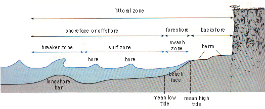
- often called the "littoral zone" by oceanographers (but not by marine ecologists) -- stretches between seaward limit of land plants and region below sea-level where sediment is not disturbed by wave action during fair weather conditions (10-20 m depth)
- foreshore/intertidal zone is the part of littoral zone that is exposed at low water when tide is out, but is covered when tide is in; active zone of beach
- backshore is above mean high tide and is only influenced by the sea when there are storm waves or exceptionally high tides; sediment here is deposited and dries out quickly (this is where coastal dunes occur)
- shoreface is seawards of the foreshore and is permanently covered by water except at exceptionally low tides
- littoral zone is divided into wave action zones: breaker zone where the waves become unstable and break; this generates the surf zone where much shallower waves are projected up the beach face to swash zone (splash zone) which is alternatively covered (the swash) and uncovered (the backwash) by water
- sediment profiles of the littoral zone show the following features:
- the berm of the backshore -- flat-topped ridge which develops at the limit of wave swash on steeply sloping features
- berm crest is high point on a beach (peaked top of berm)
- beach scarp is a vertical wall of variable height that extends from the base of the berm and is carved by wave action at high tide
- runnels are linear depressions running parallel to the shoreline; are found on shallow sloping beaches of the foreshore; are formed by sediment movement in the surf and swash zones
- swash bars are the series of low broad sand bars that are separated by the runnels
- beneath the breaker zone, a longshore bar can develop; is characteristic of some profiles in the winter when berms are generally absent
- this occurs because the summer is characterized by swell dominated waves so sediment is moved up the beach face to build berms; in the winter there are steep storm waves which destroy the berms and flatten the beach slope -- sediment of the berm is removed to form the longshore bars
- beach face (or low tide terrace) is the sloping portion of the beach, below the berm
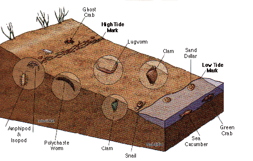
- sandy beaches are usually steep, so they drain and dry out more quickly (coarse sand beaches have more water drain out during low tide, recharging the supply of dissolved oxygen and flush away wastes); under the sand are distinguishable life zones comparable to those of rocky shores
- organisms consist of epifauna (organisms living on the surface) and infauna (organisms living below the surface); primary producers are diatoms
- upper portions are occupied by a few species of burrow-dwelling amphipods or ghost crabs
- middle portions is also populated with amphipods, lugworms (live in U-shaped burrows and eat sediment), isopods, sand crabs, polychaete worms, harpacticoid copepods (live in interstitial spaces between sand grains), gastrotrichs (live in interstitial spaces between sand grains)
- these forms are generally elongated to fit between sand grains
- lower portion is populated with polychaetes, amphipods, surf clams, cockles, sand dollars, fiddler crabs